UPDATED: 2009 March 27
About this page: Kuhnke International maintains this list of geostationary telecommunications satellites. The list is primarily intended to cover the European-African-Asian area of the globe ranging from 35 degrees west longitude to 150 degrees east longitude. Greater emphasis is placed on satellites with capacity available for two-way telecommunications services, while satellites which are primarily used for direct to home television broadcasts may not be fully represented. The list does not contain satellites which are known to be in erratic/wandering orbits or have been retired by their owners.
We encourage readers of this site to submit additional information about the operational characteristics of any particular satellite. Of particular interest is information about notable third-party teleport facilities currently pointing at a satellite (please submit details with latitude/longitude and specifications of teleport), press releases from service providers announcing leases of transponder capacity or any news regarding operational issues with a satellite. Satellite owners are also encouraged to submit press releases and updated coverage/EIRP maps. Fleet owners operating teleport facilities are welcome to submit additional information about the technical parameters and capabilities of their teleports.
New satellites due to be launched in the next 24 months will be placed in the list alongside currently operational satellites when their owner announces a longitude. Recently failed on-orbit satellites will be maintained in the list for an indeterminate period, with as much information as possible provided about the cause of the failure and owner's replacement plans. In some cases government / military owned satellites may be identified by an approximate longitude location, marked as unknown, or identified only by their NASA SPACEWARN or NORAD/COSPARS identification numbers. The list does not track military satellites in low/medium height, Molniya/tundra or other non-geostationary orbits.
Do you have new information about a satellite? Has a spot beam moved or other technical parameters changed? Contact info@kuhnke-international.com and we'll update the page.
| Longitude |
127.0 West |
| Satellite name |
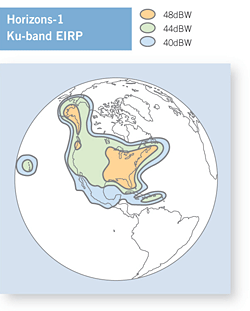
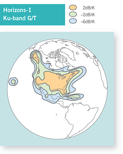
Horizons-1 (C-band capacity known as Galaxy 13) |
| Satellite name (previous or ID number) |
NASA NSSDC 2003-044A or NORAD 27954 |
| Satellite owner |
Intelsat and JSAT joint venture |
| C-band transponders and coverage region |
24 x 36 MHz with 40W TWTAs, linear polarized covering Hawaii, Alaska, North America |
| Ku-band transponders and coverage region |
24 x 36 MHz with 108W HPAs, covering Hawaii, Alaska, North America, Cuba to British Virgin Islands |
| Satellite bus type |
Boeing / Hughes 601HP |
| Launch mass |
4060 kg |
| Power (end of life) |
9.9 kW |
| Launch date |
2003-10-01 |
| Notable uplink teleports |
Intelsat Los Angeles area (Fillmore California former Panamsat teleport or Riverside California?) |
| Owner's contact email and phone |
??? |
| Known issues / fault history |
None |
| Commentary |
C-band payload controlled by Intelsat, Ku-band payload owned and operated by Horizons Satellite LLC joint venture with JSAT
Joint venture started by Panamsat and JSAT, inherited by Intelsat as part of 2006 merger |
| External data links |
N2YO orbital parameters | Lyngsat TV listing | Gunter's Space Page | Wikipedia |
|
|
|
|
|
|
|
|
| Longitude |
021.0 East |
| Satellite name |
Afristar-1 |
| Satellite name (previous or ID number) |
NASA NSSDC 1998-063A or NORAD 25515 |
| Satellite owner |
WorldSpace |
| L-band transponders and coverage region |
Three 150W TWTAs in L-band for radio coverage, X-band TT&C / Uplink |
| Satellite bus type |
EADS Eurostar 2000+ |
| Launch mass |
2750 kg |
| Power (end of life) |
5.6 kW at beginning of life, EOL power not specified |
| Launch date |
1998-10-28 |
| Notable uplink teleports |
AfriStar control center in Silver Spring MD USA, TT&C stations located in Port Louis Mauritius and Bangalore India |
| Owner's contact email and phone |
??? |
| Known issues / fault history |
Known solar power / charging system problem on Afristar-1, possible outages during periods of solar eclipse (though not as severe as Paksat-1) |
| Commentary |
Worldspace also operates AsiaStar at 105E primarily servicing radio customers in India. AsiaStar launched 2000-03.
Afristar-1 is due to be replaced by ground spare (Afristar-2) at same orbital location. May be launched in 2009 if funding permits.
Worldspace
filed for bankruptcy in US court 2008-10-17. |
| External data links |
N2YO orbital parameters | Gunter's Space Page | Wikipedia |
|
|
|
|
|
|
|
|
| Longitude |
021.5 East |
| Satellite name |
Eutelsat W6 |
| Satellite name (previous or ID number) |
Previously known as W3 when located at 007E, or NASA NSSDC 1999-018A or NORAD 25673 |
| Satellite owner |
Eutelsat |
| C-band transponders and coverage region |
None |
| Ku-band transponders and coverage region |
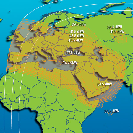
28 x 36 MHz equivalent with 10 redundant, coverage of Europe / Middle East. Steerable beam on Morocco. |
| Satellite bus type |
Alcatel AleniaSpazio (now Thales-Alenia Space) 3000B2, shares common design with Eutelsat W2 and W5 |
| Launch mass |
3180 kg |
| Power (end of life) |
Not specified, estimated 4 kW+ |
| Launch date |
1999-04-12 |
| Notable uplink teleports |
Intelsat Usingen Germany |
| Owner's contact email and phone |
??? |
| Known issues / fault history |
None |
| Commentary |
Relocated from 007 East to 021.5 East in mid 2004 to replace old Eutelsat II F-3 satellite
Position at 007 East is now occupied by Eutelsat W3A launched 2004-03-16 |
| External data links |
N2YO orbital parameters | Lyngsat TV listing | FlySat TV listing | Gunter's Space Page | Wikipedia |
|
|
|
|
|
 |
|
|
| Longitude |
025.5 East |
| Satellite name |
Eurobird 2 |
| Satellite name (previous or ID number) |
Formerly known as Hotbird 5 when located at 13E longitude, also marketed as Arabsat 2D or Badr-2 when leased to Arabsat.
NASA NSSDC 1998-057A or NORAD 25495 |
| Satellite owner |
Eutelsat |
| C-band transponders and coverage region |
None |
| Ku-band transponders and coverage region |
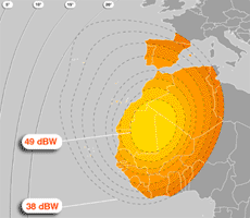
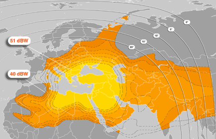
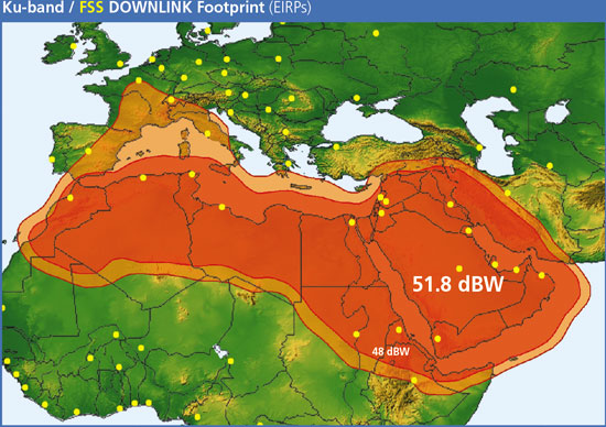
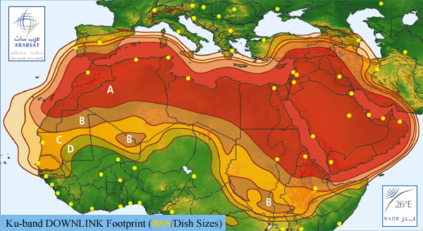
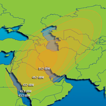
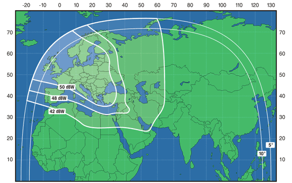
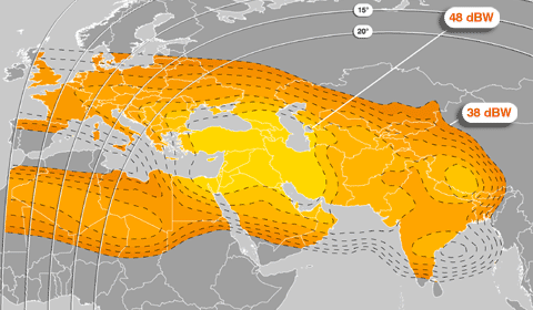
16 operational 110W TWTA transponders x 36 MHz, originally 20+. Strong 50 to 51 dBW coverage on Greece, Turkey, Syria, Iraq, Jordan, N. Egypt |
| Satellite bus type |
EADS Eurostar 2000+. Common design shared with Hot Bird 2, 3 and 4 |
| Launch mass |
3000 kg |
| Power (end of life) |
Not specified, estimated 3 kW+ |
| Launch date |
1998-10-09 |
| Notable uplink teleports |
??? |
| Owner's contact email and phone |
??? |
| Known issues / fault history |
Originally located at 13E for direct to home TV services. Suffers from solar array degradation problem common to series of Hot Bird EADS Eurostar 2000+ satellites with Fokker Aerospace solar panels. Relocated to its present longitude in 2002. Equipped with 20 Ku-band transponders but power problems allow for the simultaneous operation of only 16. |
| Commentary |
Onboard "SKYPLEX" system can multiplex multiple DVB signals into single downlink stream.
Was leased to Arabsat from 2002 to ??? and known as Arabsat 2D / BADR-2, now returned to control of Eutelsat as of 2008-September. |
| External data links |
N2YO orbital parameters | Lyngsat TV listing | FlySat TV listing | Gunter's Space Page | Wikipedia |
|
|
|
|
|
|
|
|
| Longitude |
026.0 East |
| Satellite name |
Arabsat BADR-3 |
| Satellite name (previous or ID number) |
Formerly known as Arabsat 3A when launched in 1999, or NASA NSSDC 1999-009A or NORAD 25638 |
| Satellite owner |
Arabsat |
| C-band transponders and coverage region |
None |
| Ku-band transponders and coverage region |
Hardware is 28 TWTAs for 20 active transponders, original service was 20 Ku-band x 36 MHz, only 12 transponders now operational due to power supply problem. |
| Satellite bus type |
Thales Alenia Space 3000B2 |
| Launch mass |
2708 kg |
| Power (end of life) |
Not specified, estimated approximately 2 kW |
| Launch date |
1999-02-26 |
| Notable uplink teleports |
??? |
| Owner's contact email and phone |
??? |
| Known issues / fault history |
Suffered fault in solar array drive mechanism 2001-12-07, eight transponders shut off. |
| Commentary |
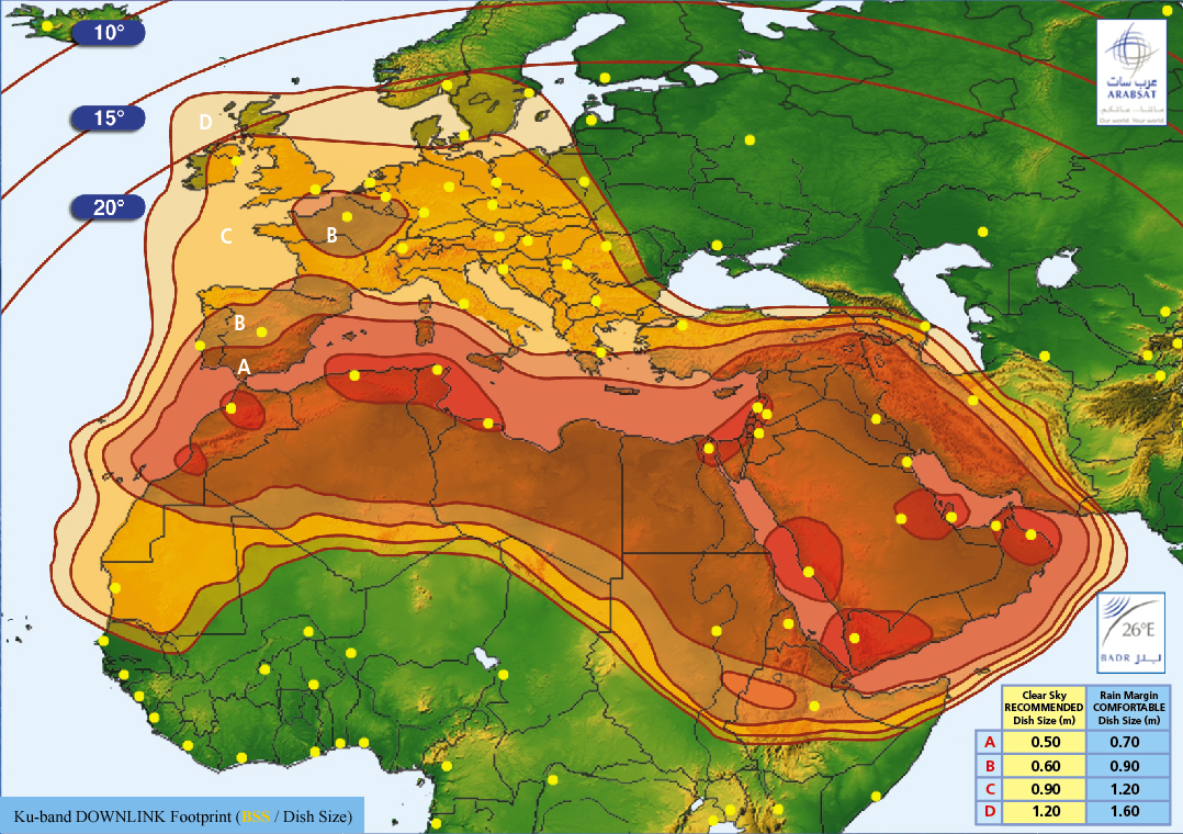
Shares 26E longitude with Arabsat BADR-4 (formerly Arabsat 4B) and Arabsat BADR-6 launched 2008-July
Badr 1 did not reach its planned orbit, when the upper stage of the Proton-M Briz-M launch vehicle failed. After evaluating a lunar fly-by maneuvre to rescue the satellite, Badr 1 was deorbited on 24.03.2006 over the pacific. |
| External data links |
N2YO orbital parameters | Lyngsat TV listing | FlySat TV listing | Gunter's Space Page | Wikipedia |
|
|
|
|
|
|
|
|
| Longitude |
026.0 East |
| Satellite name |
Arabsat BADR-4 |
| Satellite name (previous or ID number) |
Formerly known as Arabsat 4B when launched in 2006, or NASA NSSDC 2006-051A or NORAD 29526 |
| Satellite owner |
Arabsat |
| C-band transponders and coverage region |
None |
| Ku-band transponders and coverage region |
Standard Ku-band 16 LTWTAs for 12 active transponders
BSS Ku-band
20TWTAs for 20 transponders at beginning of life, 16 at EOL
Total 28 x 36 MHz Ku-band transponders |
| Satellite bus type |
Thales Alenia Space Eurostar 2000+ |
| Launch mass |
3300 kg, dry mass 1487 kg |
| Power (end of life) |
Not specified, estimated approximately 2 kW |
| Launch date |
2006-11-08 |
| Notable uplink teleports |
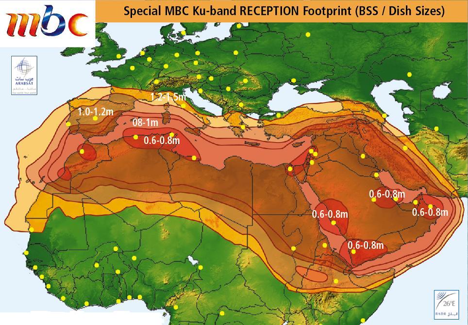
MBC |
| Owner's contact email and phone |
??? |
| Known issues / fault history |
None |
| Commentary |
Shares 26E longitude with Arabsat BADR-3 (formerly Arabsat 4B) and Arabsat BADR-6 launched 2008-July.
Badr 1 did not reach its planned orbit, when the upper stage of the Proton-M Briz-M launch vehicle failed. After evaluating a lunar fly-by maneuvre to rescue the satellite, Badr 1 was deorbited on 24.03.2006 over the pacific. |
| External data links |
N2YO orbital parameters | Lyngsat TV listing | FlySat TV listing | Gunter's Space Page | Wikipedia |
|
|
|
Ku-band Downlink Dish Sizes |
|
|
|
|
| Longitude |
026.0 East |
| Satellite name |
Arabsat BADR-6 |
| Satellite name (previous or ID number) |
Also known as Arabsat 4AR, or NASA NSSDC 2008-034B or NORAD 33154 |
| Satellite owner |
Arabsat |
| C-band transponders and coverage region |
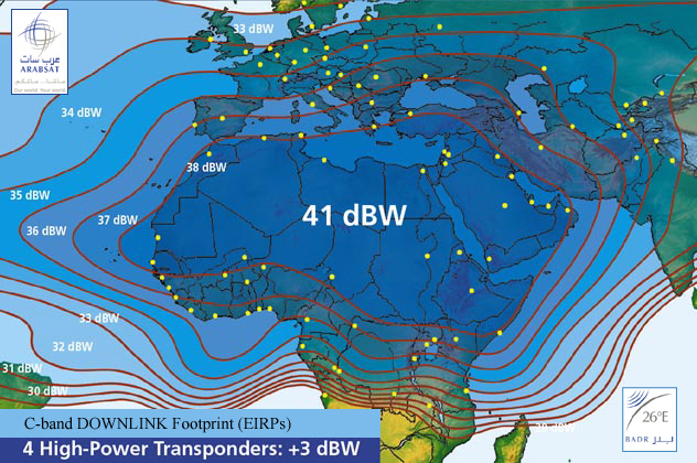
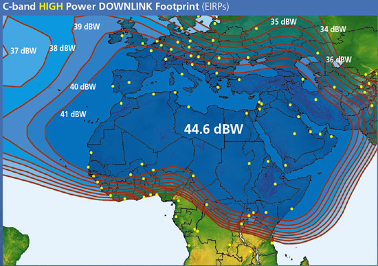
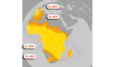
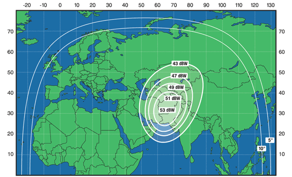
30 TWTAs in redundant configuration powering 24 transponders / 36 MHz each, 41 dBW on northern Africa and Arabia. Four high-power transponders. |
| Ku-band transponders and coverage region |
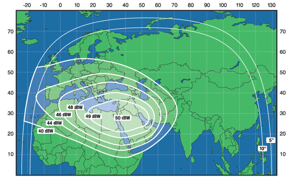
20 x 36 MHz at beginning of life, specified for 16 at end of life. Covers N. Africa, Arabia Iraq, E. Turkey |
| Satellite bus type |
EADS Eurostar 2000+ spacecraft bus with radio transponder package provided by Thales-Alenia Space |
| Launch mass |
3341 kg |
| Power (end of life) |
Not specified, estimated 5 kW+ at EOL. |
| Launch date |
2008-07-07 |
| Notable uplink teleports |
??? |
| Owner's contact email and phone |
??? |
| Known issues / fault history |
??? |
| Commentary |
Replacement satellite for BADR-1 which did not reach its intended orbit in 2006
Shares 26E longitude with Arabsat BADR-3 (formerly Arabsat 3A) and Arabsat BADR-4 (formerly Arabsat 4B)
Badr 1 did not reach its planned orbit, when the upper stage of the Proton-M Briz-M launch vehicle failed. After evaluating a lunar fly-by maneuvre to rescue the satellite, Badr 1 was deorbited on 24.03.2006 over the pacific. |
| External data links |
N2YO orbital parameters | Lyngsat TV listing | FlySat TV listing | Gunter's Space Page | Wikipedia |
|
|
|
Ku-band Downlink Dish Sizes |
|
|
|
|
| Longitude |
029.0 East |
| Satellite name |
XTAR-EUR |
| Satellite name (previous or ID number) |
NASA NSSDC 2005-005A or NORAD 28542 |
| Satellite owner |
Joint venture between Hisdesat (44%) and Loral (56%) |
| X-band transponders and coverage region |
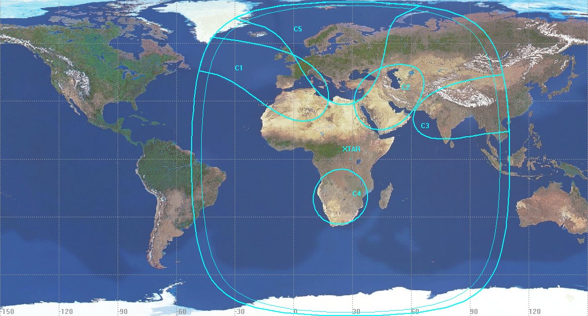
12 x ?? MHz 100W TWTA wideband NATO / Government standard operating in X-band. Redundant system with total of 19 TWTAs.
Two global beams, one fixed spot beam, four steerable spot beams |
| Satellite bus type |
Loral LS1300 |
| Launch mass |
3600 kg |
| Power (end of life) |
5.73 kW beginning of life, 3.59 kW required for operation |
| Launch date |
2005-02-12 |
| Notable uplink teleports |
TT&C antennas located in Arganda Spain and Maspalomas Spain, but control centers located in Hawley PA and Mt. Jackson VA |
| Owner's contact email and phone |
hisdesat@hisdesat.es or +34 91 449 01 49 |
| Known issues / fault history |
None |
| Commentary |
Service life advertised as 15 years
Loral 2007 SEC form 10K (published 2008-04-30) says:
We also own 56% of XTAR, LLC (“XTAR”), a joint venture between us and Hisdesat Servicios Estrategicos, S.A. (“Hisdesat”). XTAR owns and operates an X-band satellite, XTAR-EUR located at 29 o E.L., which entered service in March 2005. The satellite is designed to provide X-band communications services exclusively to United States, Spanish and allied government users throughout the satellite’s coverage area, including Europe, the Middle East and Asia. The government of Spain granted XTAR rights to an X-band license, normally reserved for government and military use, to develop a commercial business model for supplying X-band capacity in support of military, diplomatic and security communications requirements.
XTAR also leases up to eight 72 MHz X-band transponders on Spainsat, a Hisdesat owned satellite located at 30 o W.L. which entered commercial service in April 2006. These transponders, designated as XTAR-LANT, allow XTAR to provide its customers in the U.S. and abroad with additional X-band services and greater flexibility. XTAR currently has contracts to provide X-band services to the U.S. Department of State, the Spanish Ministry of Defense, the Belgium Ministry of Defense and the Danish armed forces, but the take-up rate in its service continues to be slower than anticipated. |
| External data links |
N2YO orbital parameters | Gunter's Space Pag |
|
|
|
|
|
|
|
|
| Longitude |
030.5 East |
| Satellite name |
Arabsat 2B |
| Satellite name (previous or ID number) |
NASA NSSDC 1996-063A or NORAD 24652 |
| Satellite owner |
Arabsat |
| C-band transponders and coverage region |
High power: 12 TWTAS at 36 MHz each for 8 active transponders
Medium power: 20 52W SSPAs at 36 MHz each for 14 active transponders
|
| Ku-band transponders and coverage region |
17 x 36 MHz TWTAs for 12 active transponders |
| Satellite bus type |
Alcatel (now Thales-Alenia Space) Spacebus 3000A |
| Launch mass |
2500 kg |
| Power (end of life) |
Unknown |
| Launch date |
1996-11-13 |
| Notable uplink teleports |
??? |
| Owner's contact email and phone |
??? |
| Known issues / fault history |
2007 September, experienced pointing / stationkeeping drift, approximate two hour outage. |
| Commentary |
Originally located at 021.9 East after its launch in 1996. Will be accompanied by new Arabsat-5A at 30.5E location in 2009-2010 timeframe.
|
| External data links |
N2YO orbital parameters | Lyngsat TV listing | FlySat TV listing | Gunter's Space Page | Wikipedia |
|
|
|
|
|
|
|
|
|
|
|
|
 |
 |
|
|
| Longitude |
036.0 East |
| Satellite name |
Eutelsat W4 |
| Satellite name (previous or ID number) |
NASA NSSDC 2000-028A or NORAD 26369 |
| Satellite owner |
Eutelsat |
| C-band transponders and coverage region |
None |
| Ku-band transponders and coverage region |
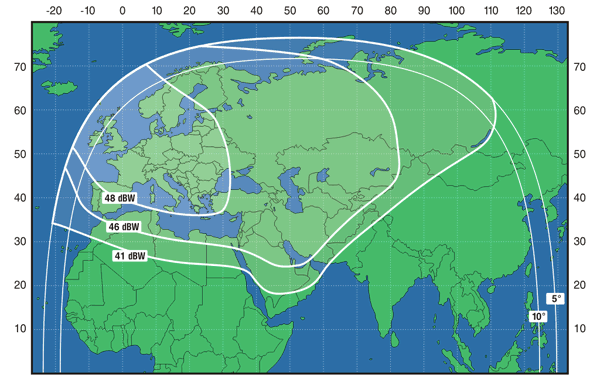
31 x 36 MHz equivalent with strong spot beams on Nigeria, Russia/Ukraine |
| Satellite bus type |
Thales-Alenia 3000B2 |
| Launch mass |
3190 kg |
| Power (end of life) |
5 kW+ |
| Launch date |
2000-05-24 |
| Notable uplink teleports |
??? |
| Owner's contact email and phone |
??? |
| Known issues / fault history |
None |
| Commentary |
Russian Ku spot beam capacity on the satellite also sold by Intersputnik (large transponder lease from Eutelsat?)
Shares 36E longitude location with SESAT-1 (Siberia Europe SATellite 1) also owned by Eutelsat.
2Q 2009 will see the launch of Eutelsat W7 at 36E, W4 or SESAT-1 may be relocated after that date.
|
| External data links |
N2YO orbital parameters | Lyngsat TV listing | FlySat TV listing | Gunter's Space Page | Wikipedia |
|
|
|
Coverage region 4 |
|
|
|
|
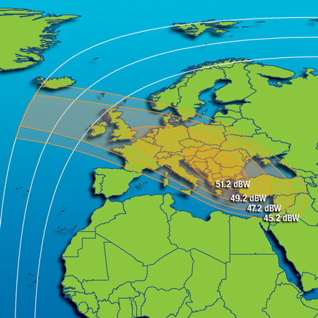
| Longitude |
042.0 East |
| Satellite name |
Turksat 1C |
| Satellite name (previous or ID number) |
NASA NSSDC 1996-040B or NORAD 23949 |
| Satellite owner |
Turksat |
| C-band transponders and coverage region |
None |
| Ku-band transponders and coverage region |
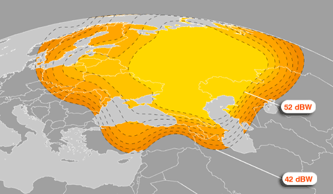
16 Ku band TWTAs with 55W power each. Unknown redundancy level of TWTAs.
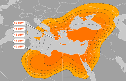
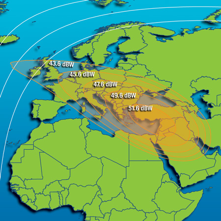
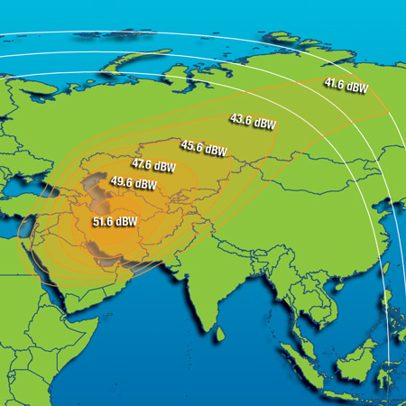
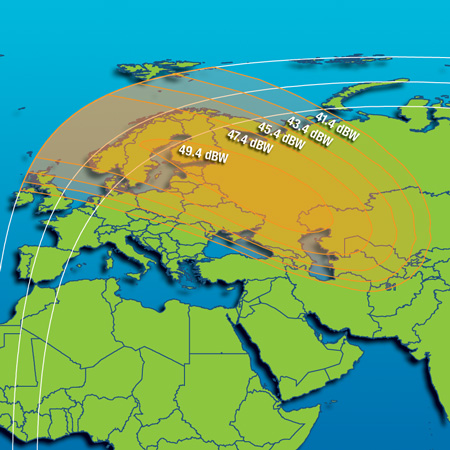
52 to 53 dBW on France / Germany, 52 to 54 dBW on Turkey. 44 to 49 dBW Central Asia.
5 x 72 MHz, 2 x 54 MHz, 9 x 36 MHz
|
| Satellite bus type |
Aerospatiale (now Thales-Alenia Space) Spacebus 2000 |
| Launch mass |
1747 kg |
| Power (end of life) |
2.8 kW |
| Launch date |
1996-07-09 |
| Notable uplink teleports |
??? |
| Owner's contact email and phone |
+90 312 615 3000 |
| Known issues / fault history |
None |
| Commentary |
Identical design to Turksat 1B (now retired), Turksat 1C was a replacement for Turksat 1A (Launch failure in 1994)
Contract lifetime 10 years. Previously located at 31E. |
| External data links |
N2YO orbital parameters | Lyngsat TV listing | FlySat TV listing | Gunter's Space Page | Wikipedia |
|
|
|
|
|
|
|
|
| Longitude |
042.0 East |
| Satellite name |
Turksat 2A |
| Satellite name (previous or ID number) |
Eurasiasat 1 or NASA NSSDC 2001-002A or NORAD 26666 |
| Satellite owner |
Turksat |
| C-band transponders and coverage region |
None |
| Ku-band transponders and coverage region |
20 x 33 MHz Ku BSS, 12 x 36 MHz Ku FSS. 110W TWTAs |
| Satellite bus type |
Thales-Alenia 3000B3 |
| Launch mass |
3535 kg |
| Power (end of life) |
9 kW |
| Launch date |
2001-01-10 |
| Notable uplink teleports |
??? |
| Owner's contact email and phone |
+90 312 615 3000 |
| Known issues / fault history |
None |
| Commentary |
Same location as newer Turksat 3A |
| External data links |
N2YO orbital parameters | Lyngsat TV listing | FlySat TV listing | Gunter's Space Page |
|
|
|
|
|
|
|
|
| Longitude |
042.0 East |
| Satellite name |
Turksat 3A |
| Satellite name (previous or ID number) |
NASA NSSDC 2008-030B or NORAD 33056 |
| Satellite owner |
Turksat |
| C-band transponders and coverage region |
None |
| Ku-band transponders and coverage region |
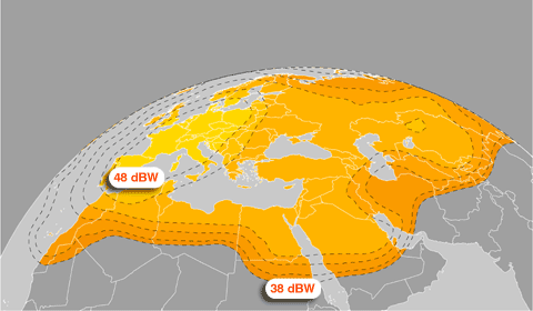
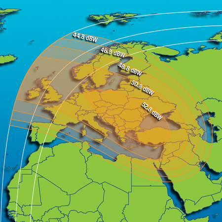
12 x 36 MHz plus 12 x 72 MHz equivalent, TWTA power not specified. Strong 50 to 52 dBW on most of Europe. |
| Satellite bus type |
Thales-Alenia 4000B2 |
| Launch mass |
3110 kg |
| Power (end of life) |
Beginning of life power about 8 kW, 6.12 kW at EOL |
| Launch date |
2008-06-12 |
| Notable uplink teleports |
??? |
| Owner's contact email and phone |
+90 312 615 3000 |
| Known issues / fault history |
None |
| Commentary |
Will be replacing services currently run on Turksat 1C |
| External data links |
N2YO orbital parameters | Lyngsat TV listing | FlySat TV listing | Gunter's Space Page |
|
|
|
|
|
|
|
|
| Longitude |
042.5 East |
| Satellite name |
NIGCOMSAT-1 |
| Satellite name (previous or ID number) |
NASA NSSDC 2007-018A or NORAD 31395 |
| Satellite owner |
NIGCOMSAT |
| C-band transponders and coverage region |
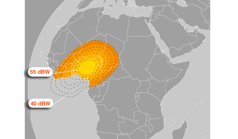
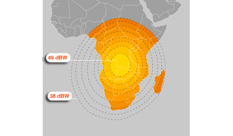
6 active / 4 redundant, 36 MHz per transponder assumed (not specified by NIGCOMSAT) |
| Ku-band transponders and coverage region |
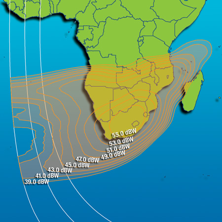
14 active / 4 redundant, 36 MHz per transponder assumed (not specified by NIGCOMSAT). Two beams, West Africa and Nigeria to Angola |
| Ka-band transponders and coverage region |
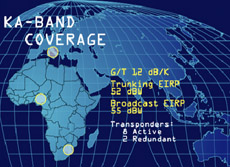
8 active / 2 redundant, ?? MHz per transponder. Used for Europe to Nigeria high capacity uplinks, and S. Africa link? |
| Satellite bus type |
Chinese DFH-4 (Dong Fang Hong 4). Transponder system manufactured by Alcatel AleniaSpazio (now Thales Alenia Space) |
| Launch mass |
5150 kg |
| Power (end of life) |
10 kW |
| Launch date |
2007-05-13 |
| Notable uplink teleports |
NIGCOMSAT Nigeria, unknown facility in Italy. |
| Owner's contact email and phone |
info@nigcomsat.org +234.9.314.5759 or +234.9.480.5909 |
| Known issues / fault history |
None |
| Commentary |
Strong 52 dBW coverage on Nigeria
DEAD as of 2008 November 15 due to solar panel or battery charging problem
|
| External data links |
N2YO orbital parameters | Lyngsat TV listing | FlySat TV listing | Gunter's Space Page | Wikipedia |
|
|
|
|
|
|
|
|
| Longitude |
044.0 East |
| Satellite name |
Thuraya-2 |
| Satellite name (previous or ID number) |
NASA NDDSC 2003-026A or NORAD 27825 |
| Satellite owner |
Thuraya |
| L-band transponders and coverage region |
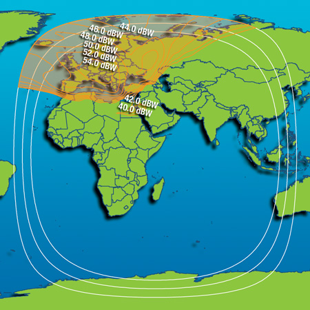
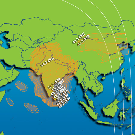
128 element L-band transponders, using 17W SSPAs. Covers hemisphere visible from 44E: Morocco to Bangladesh, Norway to Angola. |
| C-band transponders and coverage region |
Two C-band transponders unspecified MHz or wattage. Not for customer use, data downlink to Thuraya teleport. |
| Ku-band transponders and coverage region |
None |
| Satellite bus type |
Boeing 702 GEM (Geomobile), based on standard Boeing 702 bus with custom L-band 12.25 meter antenna |
| Launch mass |
5177 kg |
| Power (end of life) |
11 kW |
| Launch date |
2003-06-10 |
| Notable uplink teleports |
Thuraya UAE, located in desert along main highway between Sharjah and Fujairah |
| Owner's contact email and phone |
??? |
| Known issues / fault history |
None |
| Commentary |
Thuraya-1 suffered from greatly reduced electrical power due to fogging problem with concentrator-type solar arrays, problem not present in Thuraya-2 or Thuraya-3.
Thuraya offers mobile phone service from handheld terminals compatible with GSM networks and the proprietary Thuraya system.
The ThurayaDSL service offering provides up to 144 kbps Internet access via a portable laptop sized L-band terminal. The ThurayaDSL devices are proprietary to the Thuraya network and are similar in size to INMARSAT BGAN/RBGAN terminals. |
| External data links |
N2YO orbital parameters | Gunter's Space Page | Wikipedia |
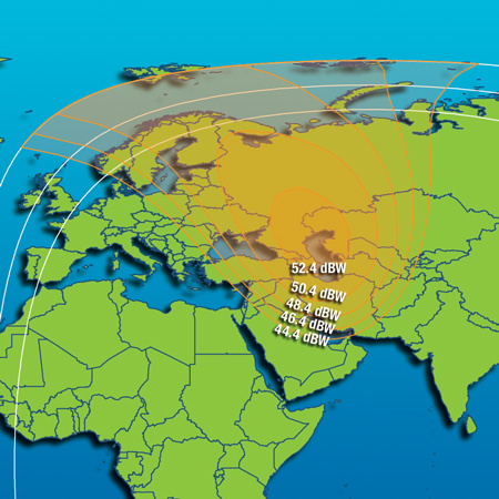
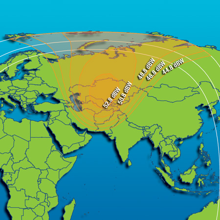
|
Coverage region 2 |
Coverage region 3 |
Coverage region 4 |
|
|
??? |
??? |
| Longitude |
045.0 East |
| Satellite name |
IS-12 (Intelsat 12) |
| Satellite name (previous or ID number) |
Previously known as Europe*Star 1, then PAS-12 (Panamsat 12), NASA NSSDC 2000-068A or NORAD 26590 |
| Satellite owner |
Intelsat, acquired in merger with Panamsat |
| C-band transponders and coverage region |
None |
| Ku-band transponders and coverage region |
30 x 36 MHz. Five beams: Europe, India, Middle East, South Africa, Southeast Asia |
| Satellite bus type |
Loral FS1300 |
| Launch mass |
4167 kg |
| Power (end of life) |
Unknown, estimated 6kW+ |
| Launch date |
2000-10-29 |
| Notable uplink teleports |
??? |
| Owner's contact email and phone |
??? |
| Known issues / fault history |
None |
| Commentary |
Acquired from Loral 2005-July, renamed to IS-12 in early 2007 following Intelsat's merger with Panamsat. |
| External data links |
N2YO orbital parameters | Lyngsat TV listing | FlySat TV listing | Gunter's Space Page | Deutsche Wikipedia |
|
|
|
|
|
|
|
|
 |
|
| Longitude |
047.5 East |
| Satellite name |
Intelsat 601 (IS-601) |
| Satellite name (previous or ID number) |
NASA NSSDC 1991-075A or NORAD 21765 |
| Satellite owner |
Intelsat |
| C-band transponders and coverage region |
29 x 36 MHz |
| Ku-band transponders and coverage region |
24 x 36 MHz |
| Satellite bus type |
Hughes HS-389 common design shared with Intelsat 601-605 |
| Launch mass |
4259 kg |
| Power (end of life) |
2.2 kW |
| Launch date |
1991-10-29 |
| Notable uplink teleports |
??? |
| Owner's contact email and phone |
??? |
| Known issues / fault history |
None |
| Commentary |
Inclined orbit operation but still listed as active on Intelsat's website as of 2008-09-16 |
| External data links |
N2YO orbital parameters | Lyngsat TV listing | Gunter's Space Page | Wikipedia |
|
|
|
|
|
|
|
|
| Longitude |
047.0 East |
| Satellite name |
SYRACUSE 3A |
| Satellite name (previous or ID number) |
NASA/NSSDC 2005-041B or NORAD 28885 |
| Satellite owner |
Government of France, Délégation générale pour l'armement. |
| Custom transponders and coverage region |
X-band NATO military standard at 7.25 to 8.4GHz, Ka band at 20.2 to 21.2GHz, SHF at 39.5 to 45.5GHz. Theoretical coverage Europe/Mideast/Africa. |
| Satellite bus type |
Thales-Alenia 4000B3 possibly customized / hardened against EMP and jamming |
| Launch mass |
3700 kg reported by one source, no official figure from owner |
| Power (end of life) |
5.64 kW reported by one source |
| Launch date |
2005-10-13 |
| Notable uplink teleports |
French military. Locations? |
| Owner's contact email and phone |
??? |
| Known issues / fault history |
None |
| Commentary |
SYRACUSE acronym stands for SYstème de RAdioCommunication Utilisant un SatellitE
SYRACUSE 3B satellite is a identical design to 3A.
The SYRACUSE program represents France's commitment to the NATO SATCOM V contract, in which 45% of the total capacity will be provided by the UK SKYNET series, 45% will be provided by the French SYRACUSE satellites and 10% will be provided by the Italian SICRAL satellite. |
| External data links |
N2YO orbital parameters | Gunter's Space Page | French Wikipedia |
|
|
|
|
|
|
|
|
| Longitude |
050.0 East |
| Satellite name |
IS-706 |
| Satellite name (previous or ID number) |
NASA NSSDC 1995-023A or NORAD 23571 |
| Satellite owner |
Intelsat |
| C-band transponders and coverage region |
42 x 36 MHz, covering west Africa |
| Ku-band transponders and coverage region |
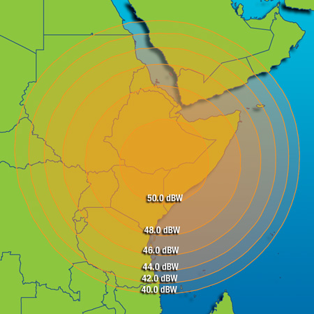
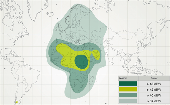
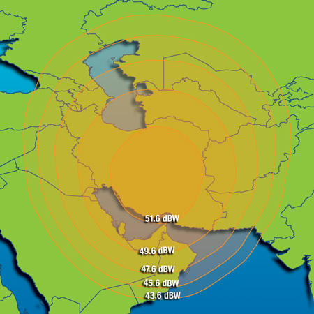
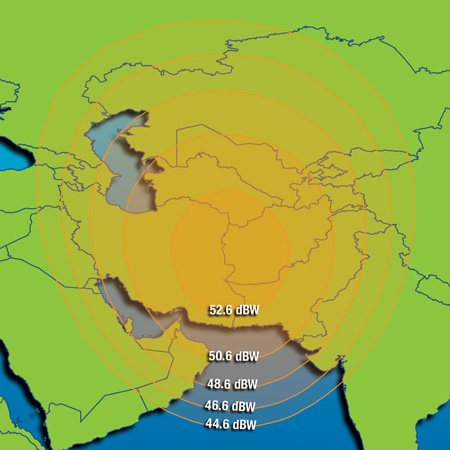
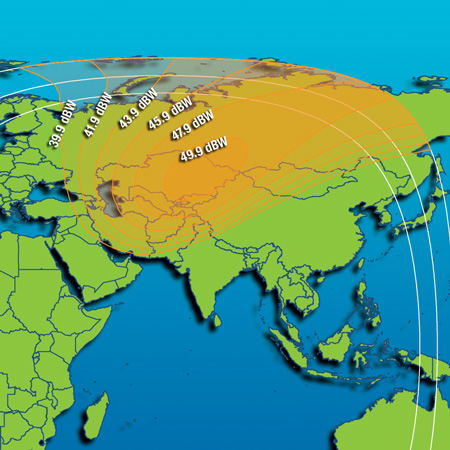
28 x 36 MHz, Ku spot 1 centered on Turkey, Ku spot 2 centered on Iran, Ku spot 3 centered on Ethiopia |
| Satellite bus type |
Loral FS1300 |
| Launch mass |
4180 kg |
| Power (end of life) |
Not known, estimated 5k |
| Launch date |
1995-05-17 |
| Notable uplink teleports |
Intelsat Fuchsstadt Germany 9 meter |
| Owner's contact email and phone |
??? |
| Known issues / fault history |
None |
| Commentary |
??? |
| External data links |
N2YO orbital parameters | Lyngsat TV listing | FlySat TV listing | Gunter's Space Page | Wikipedia |
|
|
|
|
|
|
|
|
| Longitude |
052.5 East |
| Satellite name |
Yahsat 1A |
| Satellite name (previous or ID number) |
Not launched yet, no NASA NSSDC / NORAD ID number. ETA 2010 |
| Satellite owner |
Yahsat |
| C-band transponders and coverage region |
14 x 36 MHz equivalent, Europe / Africa / Arabia |
| Ku-band transponders and coverage region |
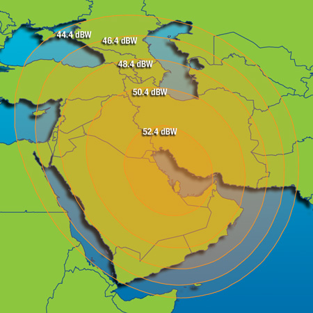
20 x 36 MHz equivalent, Beam 1: Europe / North Africa / Arabia. Beam 2: Arabia / Iraq / Iran / Afghanistan / Pakistan |
| Ka-band transponders and coverage region |
21 x 36 MHz equivalent with anti-jamming capability, some for use by UAE military |
| Satellite bus type |
EADS Eurostar 3000 |
| Launch mass |
6000 kg |
| Power (end of life) |
15 kW |
| Launch date |
LATE 2010 - EXACT DATE TO BE DETERMINED |
| Notable uplink teleports |
Yahsat UAE, Etisalat UAE, Emerging Markets Corporation Raisting Germany |
| Owner's contact email and phone |
info@yahsat.ae or +971 2 406 1111 |
| Known issues / fault history |
None |
| Commentary |
Emerging Markets Corporation has signed a deal for a significant amount of C-band transponder capacity on this satellite.
Yahsat is wholly owned by the Mubadala Development Corporation, a state owned investment arm of the government of Abu Dhabi.
Twin
satellite Yahsat 1B scheduled to be launched in 2011. Longitude location for Yahsat 1B to be determined at a later date. |
| External data links |
N2YO orbital parameters | Lyngsat TV listing | FlySat TV listing | Gunter's Space Page | Wikipedia |
|
|
|
|
|
|
|
|
| Longitude |
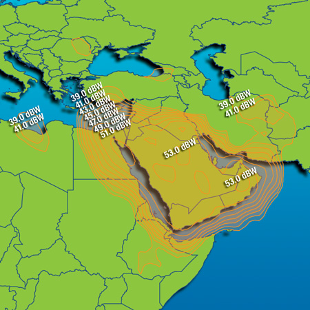
053.0 East |
| Satellite name |
Express AM22 (called SESAT-2 by Eutelsat) |
| Satellite name (previous or ID number) |
NASA NSSDC 2003-060A or NORAD 28134 |
| Satellite owner |
RSCC (Russian Satellite Communications Corporation) |
| C-band transponders and coverage region |
None |
| Ku-band transponders and coverage region |
24 x 36 MHz covering Russia and area, 103.5W power output per transponder |
| Satellite bus type |
NPO Prikladnoi Mekhaniki MSS-2500-GSO |
| Launch mass |
2500 kg |
| Power (end of life) |
6 kW estimated |
| Launch date |
2003-12-28 |
| Notable uplink teleports |
RSCC |
| Owner's contact email and phone |
??? |
| Known issues / fault history |
None |
| Commentary |
Twelve Ku-band transponders on long-term lease to Eutelsat known as SESAT-2.
RF package built by Alcatel-AleniaSpazio (now Thales Alenia Space) |
| External data links |
N2YO orbital parameters | Lyngsat TV listing | FlySat TV listing | Gunter's Space Page | Deutsche Wikipedia |
|
|
|
|
|
|
|
|
| Longitude |
053.02 East |
| Satellite name |
Skynet 4E |
| Satellite name (previous or ID number) |
NASA NSSDC 1999-009B or NORAD 25639 |
| Satellite owner |
British Government |
| X-band transponders and coverage region |
Unknown quantity / unknown MHz standard NATO military frequencies X-band transponder system. Two C-band transponders. |
| Satellite bus type |
Matra Marconi ECS Bus |
| Launch mass |
1500 kg |
| Power (end of life) |
1.2 kW |
| Launch date |
1999-02-26 |
| Notable uplink teleports |
British government. Not specified. |
| Owner's contact email and phone |
??? |
| Known issues / fault history |
None |
| Commentary |
Common satellite bus design shared by Skynet 4E, 4F.
Operated by Paradigm Secure Communications, a wholly owned subsidiary of EADS under contract with the British Ministry of Defence.
May be reaching end of expected service life due to propellant exhaustion.
|
| External data links |
N2YO orbital parameters | Gunter's Space Page | Wikipedia |
|
|
|
|
|
|
|
|
| Longitude |
056.0 East |
| Satellite name |
Bonum-1 |
| Satellite name (previous or ID number) |
NASA NSSDC 1998-068A or NORAD 25546 |
| Satellite owner |
RSCC |
| C-band transponders and coverage region |
None |
| Ku-band transponders and coverage region |
8 x 33 MHz extended Ku band downlink 17.8 GHz to 18.1 GHz covering Kazakhstan, Mongolia, central and eastern Russia |
| Satellite bus type |
Boeing/Hughes HS-376HP |
| Launch mass |
1425 kg |
| Power (end of life) |
Unspecified, estimated 1.2 kW to 2.0 kW |
| Launch date |
1998-11-22 |
| Notable uplink teleports |
RSCC, Media Most |
| Owner's contact email and phone |
??? |
| Known issues / fault history |
None |
| Commentary |
Originally located at 36E
56th Hughes HS-376 series satellite deployed. End of HS-376 generation before production changed to Hughes 601/601HP series. |
| External data links |
N2YO orbital parameters | Lyngsat TV listing | FlySat TV listing | Gunter's Space Page | Wikipedia |
|
Coverage region 2 |
Coverage region 3 |
Coverage region 4 |
|
|
|
|
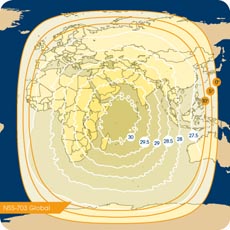
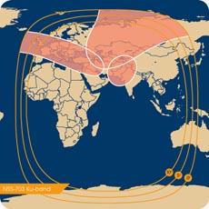
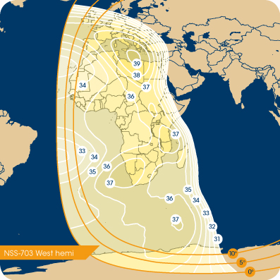
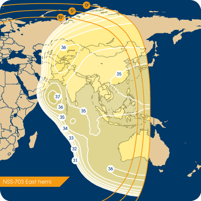
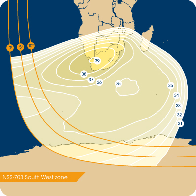
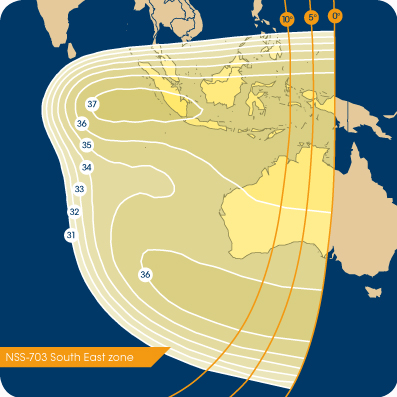
| Longitude |
057.0 East |
| Satellite name |
NSS-703 |
| Satellite name (previous or ID number) |
NASA NSSDC 1994-064A or NORAD 23305 |
| Satellite owner |
SES Newskies |
| C-band transponders and coverage region |
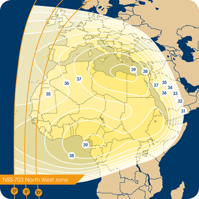
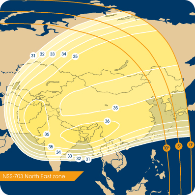
38 x 36 MHz with complete hemisphere coverage of Africa, Central Asia, East Asia, West Australia etc. |
| Ku-band transponders and coverage region |
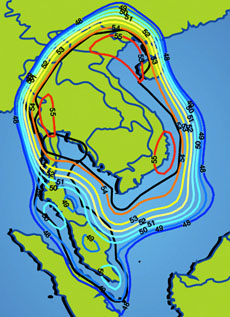
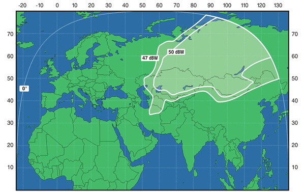
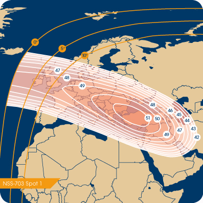
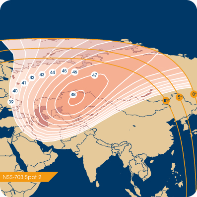
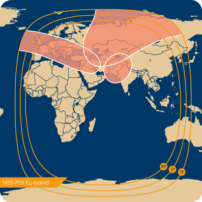
20 x 36 MHz. Spot Beam 1 on Turkey/Iraq and Europe, Spot Beam 2 on Kazakhstan / Central Asia, Spot Beam 3 on Pakistan + Afghanistan |
| Satellite bus type |
Loral FS1300, shares common design with Intelsat 701-709 series |
| Launch mass |
3695 kg |
| Power (end of life) |
3.6 kW |
| Launch date |
1994-10-06 |
| Notable uplink teleports |
Globecomm UK |
| Owner's contact email and phone |
??? |
| Known issues / fault history |
None |
| Commentary |
Originally known as Intelsat 703.
Was scheduled to be replaced in early spring 2008 by NSS-8 which blew up on the launch pad 2008-January-30.
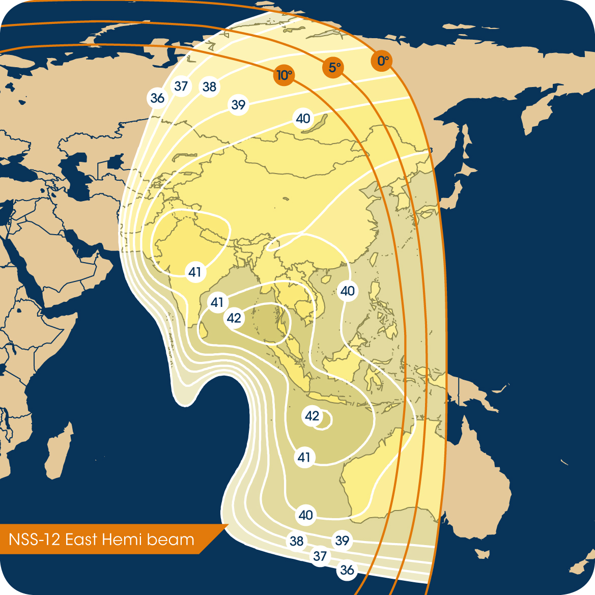
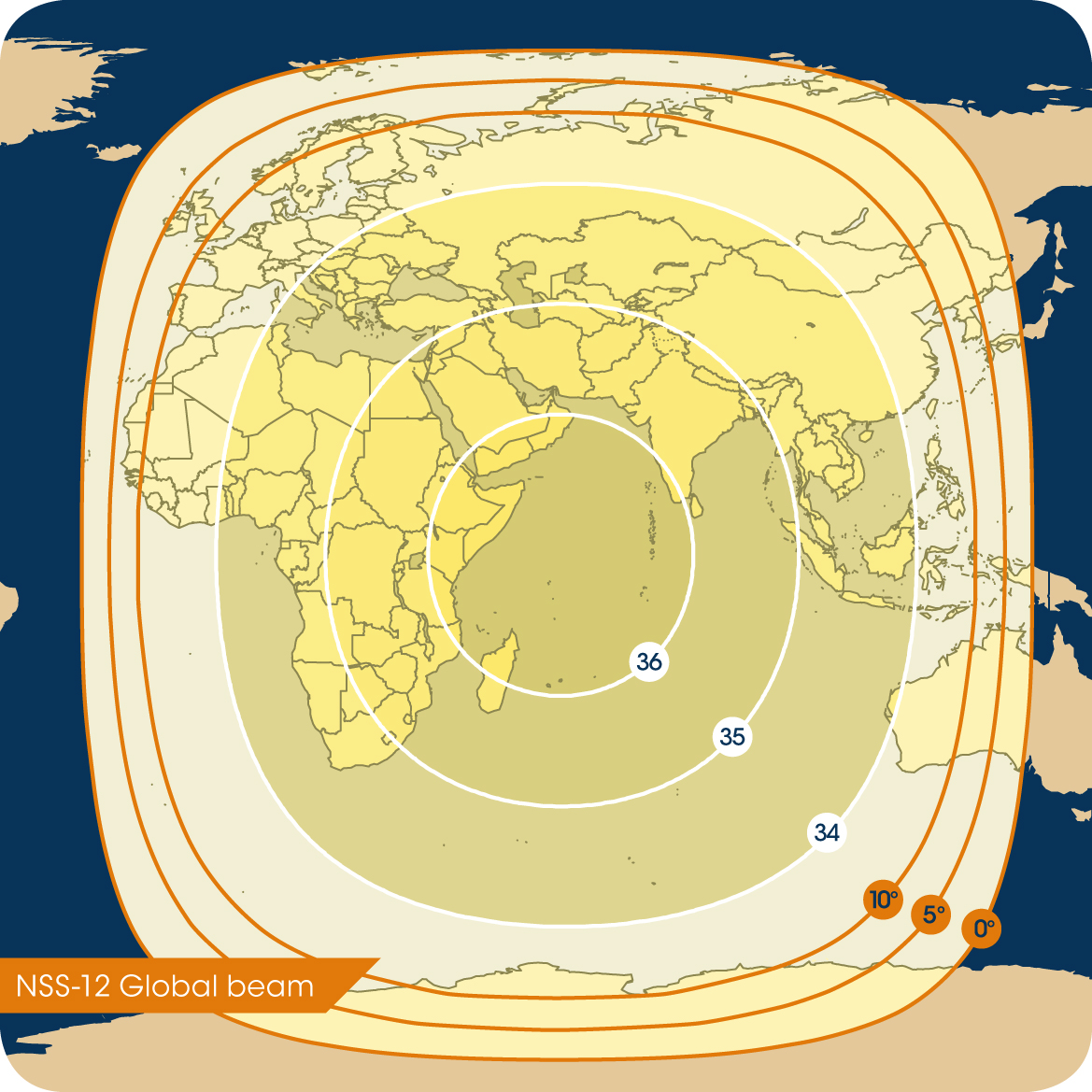
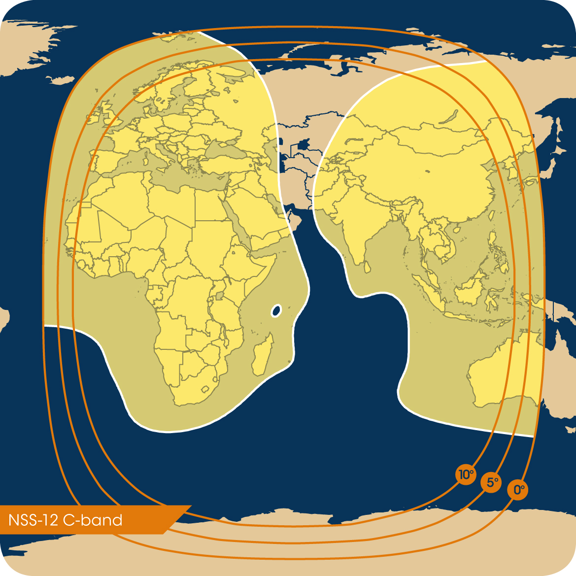
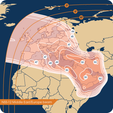
Now scheduled to be replaced by NSS-12 with 40 C-band and 48 Ku-band transponders at the same longitude location, mid-2009. |
| External data links |
N2YO orbital parameters | Lyngsat TV listing | FlySat TV listing | Gunter's Space Page | Wikipedia |
|
|
|
|
|
|
|
|
|
|
|
|
 |
 |
 |
 |
|
|
|
|
 |
 |
 |
 |
| Longitude |
057.0 East |
| Satellite name |
NSS-12 |
| Satellite name (previous or ID number) |
Not launched yet, no ID number |
| Satellite owner |
SES Newksies |
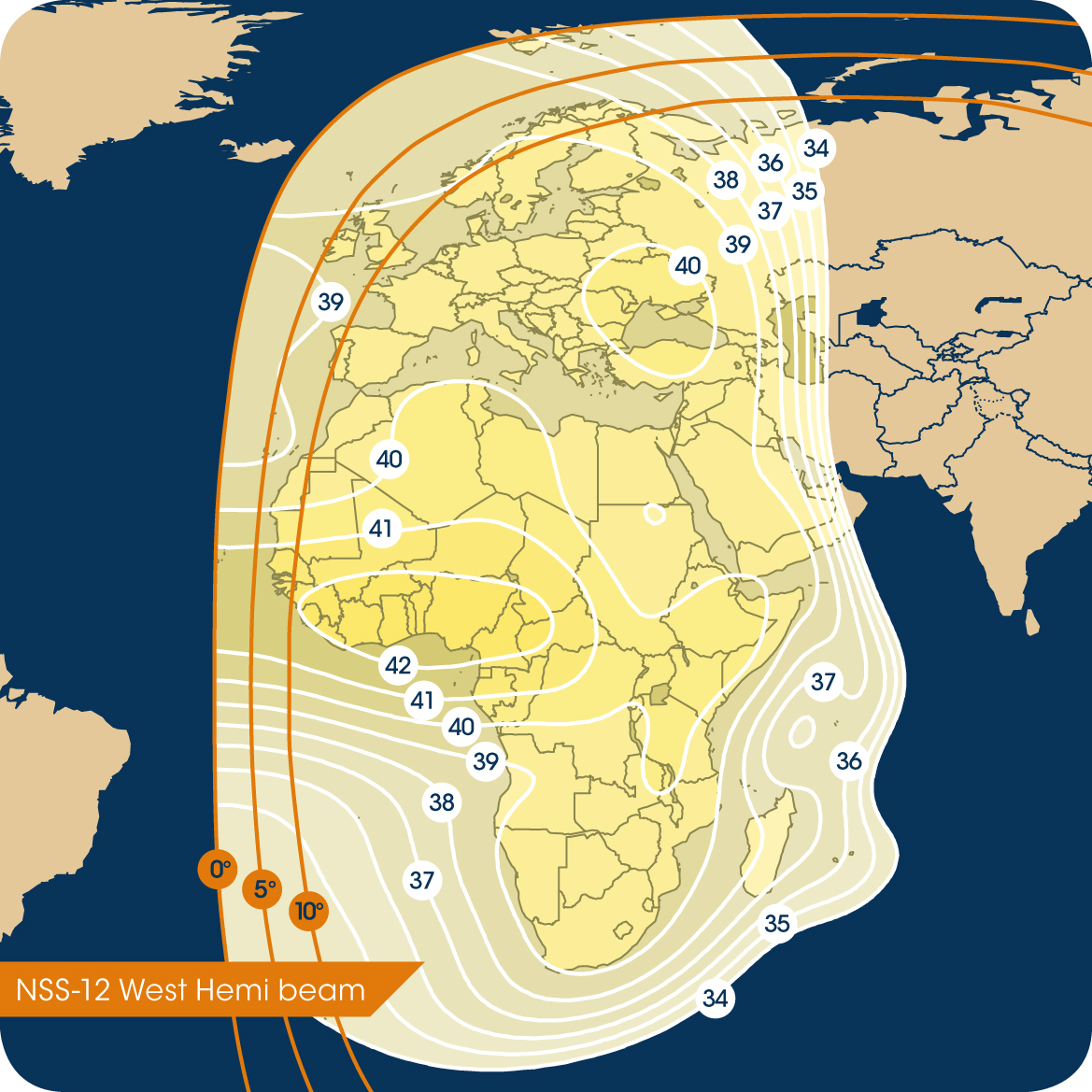
| C-band transponders and coverage region |
40 x 36 MHz covering same service areas as NSS703 |
| Ku-band transponders and coverage region |
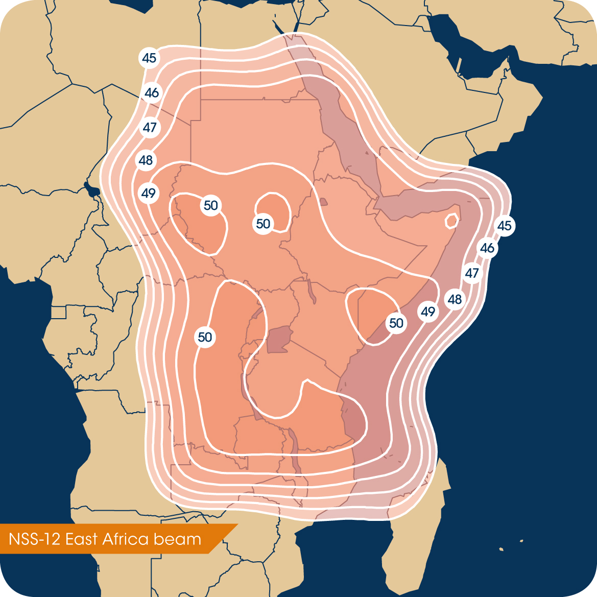
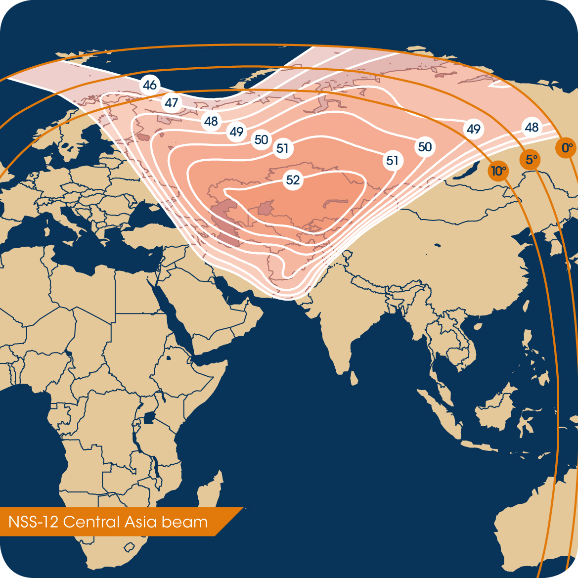
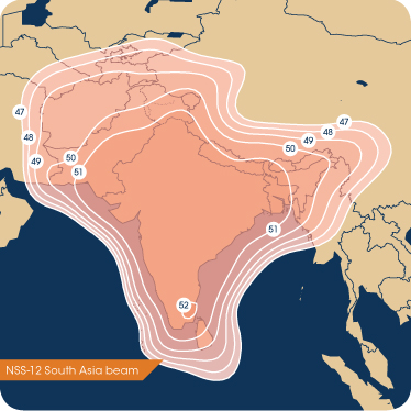
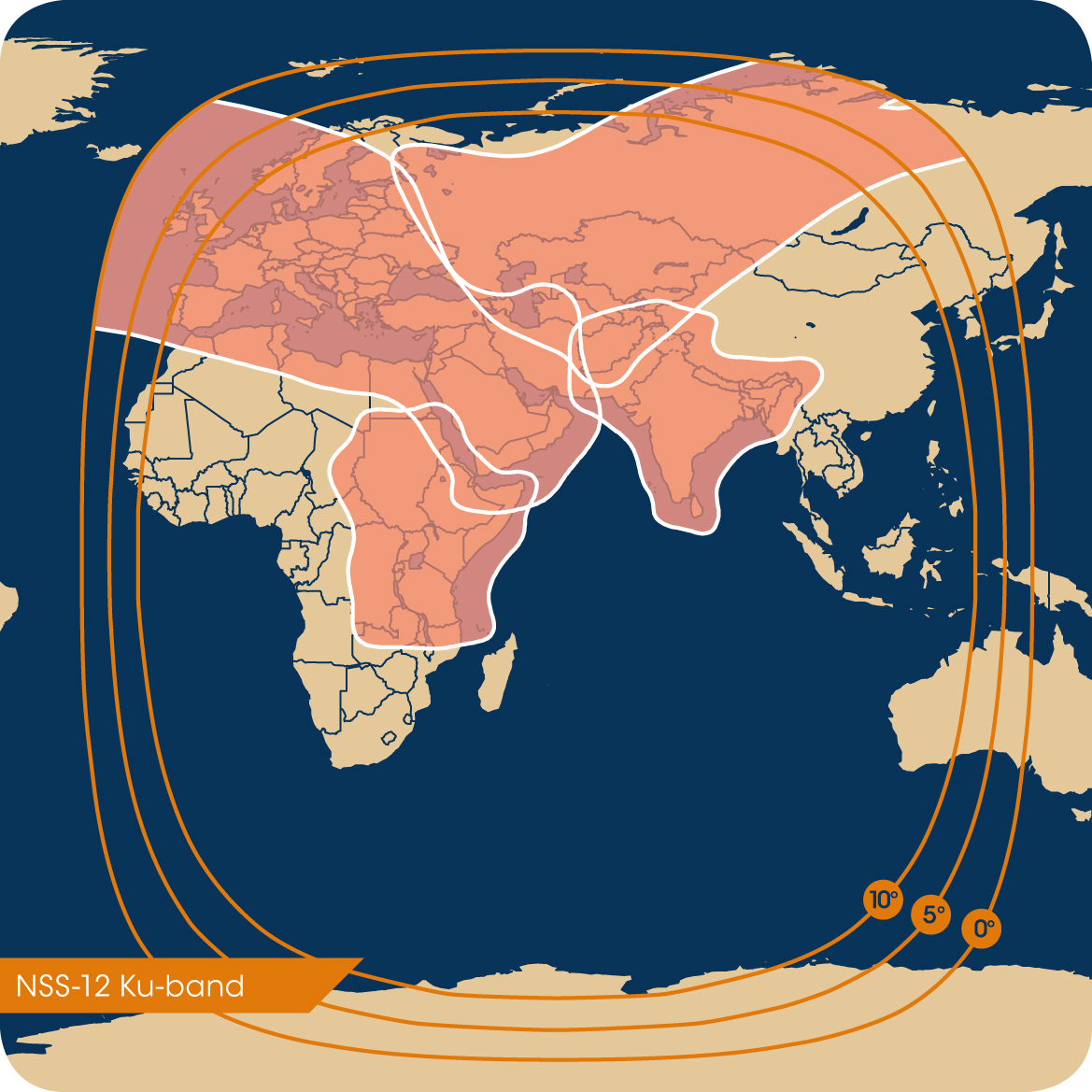
48 x 36 MHz covering similar service areas as NSS703 with new East Africa beam, Indian subcontinent, Kazakhstan beam |
| Satellite bus type |
Loral FS1300 |
| Launch mass |
Not announced but estimated 5000 kg+ |
| Power (end of life) |
10 kW+ estimate |
| Launch date |
Q2 2009, Exact date not yet announced |
| Notable uplink teleports |
??? |
| Owner's contact email and phone |
??? |
| Known issues / fault history |
None |
| Commentary |
Replacement for NSS703 which was launched in 1994, will occupy same longitude |
| External data links |
N2YO orbital parameters | Lyngsat TV listing | FlySat TV listing | Gunter's Space Page | Wikipedia |
|
|
|
|
|
|
|
|
|
|
|
|
|
|
|
|
|
|
|
|
|
|
|
|
| Longitude |
060.0 East |
| Satellite name |
Intelsat 904 (IS-904) |
| Satellite name (previous or ID number) |
NASA NSSDC 2002-007A or NORAD 27380 |
| Satellite owner |
Intelsat |
| C-band transponders and coverage region |
76 x 36 MHz covering hemisphere |
| Ku-band transponders and coverage region |
22 x 36 MHz covering ??? |
| Satellite bus type |
Loral LS-1300HL |
| Launch mass |
4725 kg |
| Power (end of life) |
8 kW |
| Launch date |
2002-02-23 |
| Notable uplink teleports |
Fuchsstadt 32m C-band, Hong Kong 32m C-band |
| Owner's contact email and phone |
??? |
| Known issues / fault history |
None |
| Commentary |
Shares common design with IS-901 through IS-907 all launched in 2001-2003. IS-90x series intended to replace IS-60x series |
| External data links |
N2YO orbital parameters | Lyngsat TV listing | FlySat TV listing | Gunter's Space Page | Wikipedia |
|
|
|
|
|
|
|
|
| Longitude |
062.0 East |
| Satellite name |
Intelsat 902 (IS-902) |
| Satellite name (previous or ID number) |
NASA NSSDC 2001-039A or NORAD 26900 |
| Satellite owner |
Intelsat |
| C-band transponders and coverage region |
76 x 36 MHz covering southern half of Africa, East Asia |
| Ku-band transponders and coverage region |
22 x 36 MHz covering Arabia/Iraq/Iran region, beam 2 on central Europe |
| Satellite bus type |
Loral LS-1300HL |
| Launch mass |
4725 kg |
| Power (end of life) |
8 kW |
| Launch date |
2001-08-30 |
| Notable uplink teleports |
??? |
| Owner's contact email and phone |
??? |
| Known issues / fault history |
None |
| Commentary |
Shares common design with IS-901 through IS-907 all launched in 2001-2003. IS-90x series intended to replace IS-60x series |
| External data links |
N2YO orbital parameters | Lyngsat TV listing | FlySat TV listing | Gunter's Space Page | Wikipedia |
|
|
|
|
|
|
|
|
| Longitude |
064.0 East |
| Satellite name |
Intelsat 906 (IS-906) |
| Satellite name (previous or ID number) |
NASA NSSDC 2002-041A or NORAD 27513 |
| Satellite owner |
Intelsat |
| C-band transponders and coverage region |
72 x 36 MHz covering most of Africa, second beam on central Asia / Russia, third beam on East Asia |
| Ku-band transponders and coverage region |
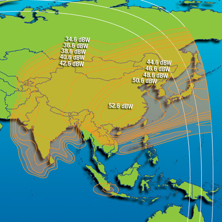
22 x 36 MHz with beams for Iran / Afghanistan / Pakistan and India / Nepal / Bangladesh regions |
| Satellite bus type |
Loral LS-1300HL |
| Launch mass |
4725 kg |
| Power (end of life) |
8 kW |
| Launch date |
2002-09-06 |
| Notable uplink teleports |
??? |
| Owner's contact email and phone |
??? |
| Known issues / fault history |
None |
| Commentary |
Shares common design with IS-901 through IS-907 all launched in 2001-2003. IS-90x series intended to replace IS-60x series.
Replaced Intelsat 804 at 64.0E, IS-804 was moved in 2003 to 176E provide south Pacific region services, IS-804 failed 2005-January. |
| External data links |
N2YO orbital parameters | Lyngsat TV listing | FlySat TV listing | Gunter's Space Page | Wikipedia |
|
|
|
|
|
|
|
|
| Longitude |
064.0 East |
| Satellite name |
Intelsat 704 (IS-704) |
| Satellite name (previous or ID number) |
NASA NSSDC 1995-001A or NORAD 23461 |
| Satellite owner |
Intelsat |
| C-band transponders and coverage region |
42 x 36 MHz centered on Iran, also good Central Asia coverage, western half of Russia |
| Ku-band transponders and coverage region |
20 x 36 MHz |
| Satellite bus type |
Loral LS-1300, shares common design with rest of Intelsat 701-709 series and SES Newskies NSS703 |
| Launch mass |
3656 kg |
| Power (end of life) |
3.6 kW |
| Launch date |
1995-01-10 |
| Notable uplink teleports |
Fuchsstadt 16 meter C-band |
| Owner's contact email and phone |
??? |
| Known issues / fault history |
None |
| Commentary |
High dBW Ku-band service for Kazakhstan |
| External data links |
N2YO orbital parameters | Lyngsat TV listing | FlySat TV listing | Gunter's Space Page | Wikipedia |
|
|
|
|
|
|
|
|
| Longitude |
068.5 East |
| Satellite name |
Intelsat 7 (IS-7) formerly known as PAS-7 |
| Satellite name (previous or ID number) |
PAS-7 when operated by Panamsat before merger with Intelsat, or NASA NSSDC 1998-052A or NORAD 25473 |
| Satellite owner |
Intelsat |
| C-band transponders and coverage region |
14 x 36 MHz at 100W power each, originally had 30 Ku band transponders before 2001 solar panel problem |
| Ku-band transponders and coverage region |
30 x 36 MHz at 50W power each, covers ??? |
| Satellite bus type |
Loral LS1300 |
| Launch mass |
3838 kg |
| Power (end of life) |
Unknown / not specified |
| Launch date |
1998-09-16 |
| Notable uplink teleports |
??? |
| Owner's contact email and phone |
??? |
| Known issues / fault history |
On 2001-09-06 spacecraft exited eclipse, solar panel fault caused permanent loss of 25% power capacity. |
| Commentary |
At same longitude as IS-10 (former PAS-10) Indian Ocean region satellite |
| External data links |
N2YO orbital parameters | Lyngsat TV listing | FlySat TV listing | Gunter's Space Page | Wikipedia |
|
|
|
|
|
|
|
|
|
|
|
|
|
|
|
|
| Longitude |
068.5 East |
| Satellite name |
Intelsat 10 (IS-10) formerly known as PAS-10 |
| Satellite name (previous or ID number) |
??? |
| Satellite owner |
??? |
| C-band transponders and coverage region |
??? |
| Ku-band transponders and coverage region |
??? |
| Satellite bus type |
??? |
| Launch mass |
??? |
| Power (end of life) |
??? |
| Launch date |
??? |
| Notable uplink teleports |
??? |
| Owner's contact email and phone |
??? |
| Known issues / fault history |
None |
| Commentary |
Telenor owns eighteen 36 MHz-equivalent Ku-band transponders of this satellite's payload (Source: Intelsat 2007 form 10K) |
| External data links |
N2YO orbital parameters | Lyngsat TV listing | FlySat TV listing | Gunter's Space Page | Wikipedia |
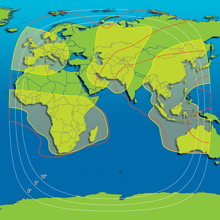
Coverage region 1 |
Coverage region 2 |
Coverage region 3 |
Coverage region 4 |
|
|
|
|
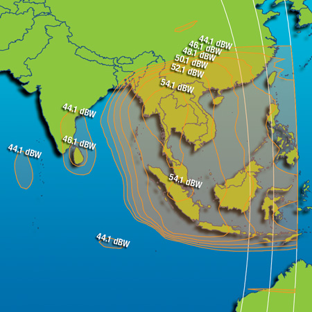
| Longitude |
070.5 East |
| Satellite name |
Eutelsat W5 |
| Satellite name (previous or ID number) |
Known as Eutelsat W1 before pre-launch accident, repaired and launched as W5. Also NASA NSSDC 2002-051A or NORAD 27554 |
| Satellite owner |
Eutelsat |
| C-band transponders and coverage region |
None |
| Ku-band transponders and coverage region |
24 x 36 MHz with 10 redundant, Wide beam coverage of Europe / Middle East / Central Asia / India, spot beams on Arabia and East Asia. |
| Satellite bus type |
Alcatel AleniaSpazio (now Thales Alenia Space) 3000B2 |
| Launch mass |
3170 kg |
| Power (end of life) |
Not specified, estimated 4 kW+ |
| Launch date |
2001-11-20 |
| Notable uplink teleports |
??? |
| Owner's contact email and phone |
??? |
| Known issues / fault history |
Originally known as Eutelsat W1, damaged during RF testing by fire suppression apparatus. Repaired and launched as W5. |
| Commentary |
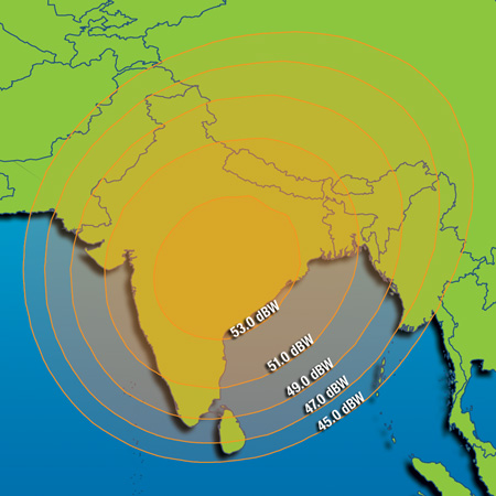
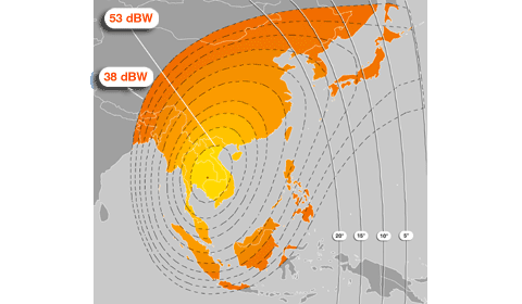
High strength 53 dBW coverage of Arabia and Vietnam areas. |
| External data links |
N2YO orbital parameters | Lyngsat TV listing | FlySat TV listing | Gunter's Space Page | Wikipedia |
|
|
|
|
|
|
|
|
| Longitude |
083.0 East |
| Satellite name |
INSAT-2E (APR-1) |
| Satellite name (previous or ID number) |
??? |
| Satellite owner |
ISRO |
| C-band transponders and coverage region |
??? |
| Ku-band transponders and coverage region |
??? |
| Satellite bus type |
??? |
| Launch mass |
??? |
| Power (end of life) |
??? |
| Launch date |
??? |
| Notable uplink teleports |
??? |
| Owner's contact email and phone |
??? |
| Known issues / fault history |
None |
| Commentary |
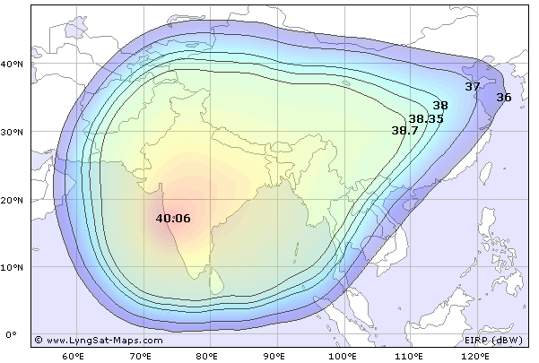
Intelsat 2007 form 10K says:
In addition to our owned satellites, as of December 31, 2007, we leased capacity on the APR-1, pursuant to an agreement with the Government of India, Department of Space, INSAT Programme Office. Under this agreement with the Government of India, we may lease eleven 36 MHz equivalent transponders on APR-1 through May 30, 2009. We have the right to extend this agreement until the APR-1 has reached the end of its service life, which is currently expected to be May 2012. |
| External data links |
N2YO orbital parameters | Lyngsat TV listing | FlySat TV listing | Gunter's Space Page | Wikipedia |
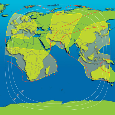
Coverage region 1 |
Coverage region 2 |
Coverage region 3 |
Coverage region 4 |
|
|
|
|
| Longitude |
087.5 East |
| Satellite name |
ChinaStar-1 (known as Zhongwei-1 in China) |
| Satellite name (previous or ID number) |
NASA NSSDC 1998-033A or NORAD 25354 |
| Satellite owner |
China Orient Satellite Telecommunications Company |
| C-band transponders and coverage region |
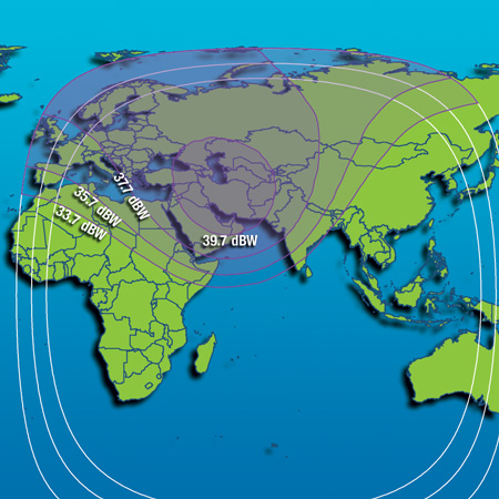
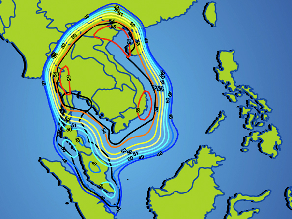
18 transponders configured as 12 x 36 MHz + 6 x 72 MHz, each transponder uses 45W TWTA. 41 dBW EIRP in beam center. |
| Ku-band transponders and coverage region |
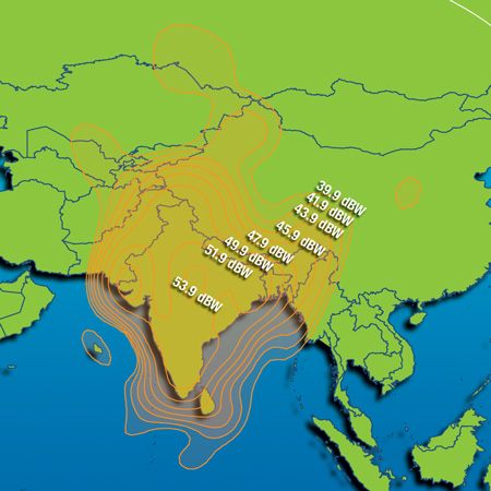
20 transponders configured as 16 x 36 MHz using 85W TWTA, additional 4 x 72 MHz using 125W TWTA. 52/54 dBW EIRP in beam center, |
| Satellite bus type |
Lockheed Martin A2100A |
| Launch mass |
2984 kg |
| Power (end of life) |
8.39 kW beginning of life spec, 6.79 kW at end of life/EOL |
| Launch date |
1998-05-30 |
| Notable uplink teleports |
China Orient says: "The TT&C Station of China Orient, with a team of high level , high quality and high efficiency, is located at Dongbeiwang, Haidian District , Beijing, about two kilometers away from Shangdi High-tech Development Zone. " |
| Owner's contact email and phone |
real@chinaorient.com.cn or (8610)64242370 |
| Known issues / fault history |
None |
| Commentary |
Expected operational lifetime 15 years.
Good C-band coverage on Afghanistan / Pakistan / N. India / Nepal for eastbound VSAT links to Hong Kong and Singapore.
|
| External data links |
N2YO orbital parameters | Lyngsat TV listing | FlySat TV listing | Gunter's Space Page | Wikipedia |
|
|
|
|
|
|
|
|
| Longitude |
098.5 East |
| Satellite name |
ProtoStar-1 |
| Satellite name (previous or ID number) |
NASA NSSDC 2008-034A or NORAD 33153 |
| Satellite owner |
ProtoStar |
| C-band transponders and coverage region |
34 x 36 MHz transponders + 2 x 72 MHz covering hemispheric region, 36W TWTAs |
| Ku-band transponders and coverage region |
Beam One: 10 x 36 MHz transponders with 125W TWTAs covering India, Nepal, Bangladesh.
Beam Two: 6 x 72 MHz transponders with 125W TWTAs covering Southeast Asia. |
| Satellite bus type |
Loral LS1300 series |
| Launch mass |
4100 kg |
| Power (end of life) |
11 kW |
| Launch date |
2008-07-07 |
| Notable uplink teleports |
Singapore, also likely many DTH TV channels uplinked from Indian subcontinent. |
| Owner's contact email and phone |
USA HQ phone +1-415-814-8100 , Singapore +65-6838-5122 |
| Known issues / fault history |
None. |
| Commentary |
Originally ordered by Chinasat as Chinasat-8 for launch in late 1999, US export control regulations prevented launch of satellite on Long March series rockets. Chinasat reached a settlement with Loral in 2005 which allowed it to sell the satellite to a third party. Construction completed by Loral and ProtoStar with customizations for 98.5E market.
Expected service life 13 to 16 years, assuming configuration similar to other LS1300 spacecraft.
Occupies an orbital position registered to Russia/Intersputnik, agreement in place to use Intersputnik's location via filing with ITU.
|
| External data links |
N2YO orbital parameters | Lyngsat TV listing | FlySat TV listing | Gunter's Space Page |
|
|
|
|
|
|
 |
|
| Longitude |
105.0 East |
| Satellite name |
Asiastar |
| Satellite name (previous or ID number) |
NASA NSSDC 2000-016A or NORAD 26107 |
| Satellite owner |
WorldSpace |
| L-band transponders and coverage region |
Three 150W TWTAs in L-band for radio coverage, X-band TT&C / Uplink |
| Satellite bus type |
EADS Eurostar 2000+ |
| Launch mass |
2750 kg |
| Power (end of life) |
5.6 kW at beginning of life, EOL power not specified |
| Launch date |
2000-03-21 |
| Notable uplink teleports |
AsiaStar control center in Melbourne Australia, TT&C stations located in Port Louis Mauritius and Bangalore India |
| Owner's contact email and phone |
??? |
| Known issues / fault history |
Design lifetime of 12 years. Identical satellite bus and transponder design to Africastar-1. |
| Commentary |
Worldspace also operates Africastar-1 at 021.0 East primarily servicing radio customers in Africa/Europe.
Worldspace
filed for bankruptcy in US court 2008-10-17. |
| External data links |
N2YO orbital parameters | Gunter's Space Page | Wikipedia |
|
|
|
|
|
|
|
|
| Longitude |
125.0 East |
| Satellite name |
Sinosat-3 |
| Satellite name (previous or ID number) |
NASA NSSDC 2007-021A or NORAD 31577 |
| Satellite owner |
Sinosat |
| C-band transponders and coverage region |
10 x 36 MHz transponders with >40 dBW EIRP in China, reported 36 dBW in Southeast Asia and surrounding region. |
| Ku-band transponders and coverage region |
None |
| Satellite bus type |
CAST (China Academy of Space Technology) DFH-3 three axis stabilized (Dong Feng Hua) |
| Launch mass |
2200 kg |
| Power (end of life) |
Estimated 4.5 kW range, not specified by owners |
| Launch date |
2007-05-31 |
| Notable uplink teleports |
Sinosat satellite control center in northern Beijing suburbs |
| Owner's contact email and phone |
Sales / marketing: +86 10 68083298, technical support Tel: +86 10 80728550 and +86 10 80728866-131~139 , HQ +86 10 68083299 |
| Known issues / fault history |
DFH-3 and DFH-4 series satellites have exhibited a variety of anomalous on-orbit behaviors including failure to deploy solar panels immediately after launch, early total power system failures (as in the case of NigComSat-1 which ceased operations less than one year after its start of service). |
| Commentary |
Expected operational lifetime 8 years as specified by Sinosat website.
Shares common DFH-3 bus design with:
Beidou-1 series low earth orbit navigation system satellites, BD-1A through BD-1D launched 2000 to 2007.
Beidou-2 series MEO navigation system satellites, BD-2A, planned launch series of 10 satellites from 2007 to ???
FH-1 / FH-2, (Feng Huo) Chinese military satellites launched in 2000 and 2006 , UHF military SATCOM (Ka-band and above Ka-band?)
ST-1 (Shen Tong) Chinese military satellite launched 2003-11-14, reportedly used for Ku-band military SATCOM with steerable spot beams.
Chinasat-6 and Chinasat-6A, first DFH-3 series satellites launched in 1994 and 1997. History of attitude control problems / early fuel exhaustion.
|
| External data links |
N2YO orbital parameters | Lyngsat TV listing| Gunter's Space Page | Wikipedia |
|
|
|
|
|
|
|
|
| Longitude |
146.0 East |
| Satellite name |
Agila-2 |
| Satellite name (previous or ID number) |
NASA NSSDC 1997-042A or NORAD 24901 |
| Satellite owner |
Mabuhaysat, a subsidiary of PLDT, incumbent local exchange phone company in the Philippines |
| C-band transponders and coverage region |
24 x 36 MHz standard frequency range at 27W power, 42 dBW peak.
6 x 36 MHz extended frequency range (Up: 6587 - 6723 MHz / Down: 3562 - 3698 MHz) at 27W power, 42dBW peak.
|
| Ku-band transponders and coverage region |
24 x 36 MHz with 110W power each, 55W dBW peak ranging to 48 dBW at edge of coverage. |
| Satellite bus type |
Loral FS1300 series |
| Launch mass |
2820 kg |
| Power (end of life) |
8.2 kW |
| Launch date |
1997-08-19 |
| Notable uplink teleports |
Mabuhaysat Subic Bay Philippines, facility constructed by Loral as part of turnkey package. |
| Owner's contact email and phone |
HQ: Tel: +63 47 2529012, : +63 47 2529004 loc 217/206 , Makati Office Tel: +63 2 8875788, info@mabuhaysat.com |
| Known issues / fault history |
None. |
| Commentary |
Design lifetime specified as 15 years. Capacity on this satellite also sold by ProtoStar.
Spot beam coverage on Hawaii for turn around coverage to continental United States.
|
| External data links |
N2YO orbital parameters | Lyngsat TV listing | FlySat TV listing | Gunter's Space Page |
|
|
|
|
|
|
|
|
| Longitude |
000.0 East |
| Satellite name |
??? |
| Satellite name (previous or ID number) |
??? |
| Satellite owner |
??? |
| C-band transponders and coverage region |
??? |
| Ku-band transponders and coverage region |
??? |
| Satellite bus type |
??? |
| Launch mass |
??? |
| Power (end of life) |
??? |
| Launch date |
??? |
| Notable uplink teleports |
??? |
| Owner's contact email and phone |
??? |
| Known issues / fault history |
None |
| Commentary |
??? |
| External data links |
N2YO orbital parameters | Lyngsat TV listing | FlySat TV listing | Gunter's Space Page | Wikipedia |
Coverage region 1 |
Coverage region 2 |
Coverage region 3 |
Coverage region 4 |
|
|
|
|
|


.png)
.png)
.png)
.png)
.png)
.png)
.png)


